Showing posts with label Insurance. Show all posts

Wednesday, September 25, 2013

Centerpointe drainage, Part 2

Going back to the POA email blast from August 31, and following up on my initial post of September 5, I'm going to expound on the advisory issued by the POA regarding our subdivision sewage system. 

That may not seem like a very delectable blog topic to you, but in the event of a sewage system failure, trust me - you are going to become really interested in how it functions, really quickly.  In fact, at any such future point where you've been forced to live without a toilet for X amount of time, it would become your ONLY topic of concern (lack of a/c would be a distant second). 

Before I start, remember, I am not an engineer and I am not a POA member and this blog is not an instrument of the POA.  But I can take the POA's information and attempt to translate it using pictures so that it's easier for non-technical residents to understand, which is what I'm going to do here.  Because when people understand underlying issues, they tend to make more appropriate behavioral decisions. 

So let's start with what was emailed on August 31, emphasis mine: 

Also good to note is that in the event of power loss - our sewer/waste lift/pump station will not pump waste out of the sewer lines. Thus as I mentioned above- the [sewage] that was flowing to the lift station will now flow back to Cypress/White Oak Pointes. If we [lose] power for any extended amount of time - residents are urged not only by the city and county to fill your bathtubs for cooking needs and refrain from flushing your toilets until instructed to do so, but I would think that all neighbors EAST of Lilac Pointe would insist on it!

OK, it doesn't get more ominous-sounding than that, but what the heck does it all mean?!

SHORT VERSION:  We're all in this subdivision thing together.  If you receive a text or email blast instructing you not to generate wastewater during any particular emergency situation, take it very seriously because they're not kidding.  Even if we still have good water pressure, we might not have sewage transfer capability, because the two are not directly related.  Don't assume that just because we have one, we also have the other. 

LONG VERSION:  In order to begin understanding sewage management, all you need to do is remember that immortal adage, "Sh*t rolls downhill."  That's what's happening from each of your houses and the rest of what happens is mostly a consequence of that. 

Let's start from the very beginning, because many residents didn't witness the construction of their own houses, and of those who did, many didn't understand what they were seeing.
Inside your slab are numerous PVC lines which connect your sinks, showers, and toilets to the sewer service line which leads from your house.  This is a picture of an early phase of construction where the lines have been laid but the concrete slab is not yet poured.  The tradesmen put temporary caps on all the lines so that they could test for water-tightness and also so that no soil would get accidentally pushed into the open ends. 
Somebody correct me if I'm wrong, but I suspect that all adjacent pairs of houses share sewer clean-out lines in Centerpointe, rather than each house having its own clean-out.  The sewer clean-out is that baby blue pipe in the center (that particular one got busted by a backhoe and had to be replaced before this area was backfilled).  You can see white lines leading from each house and converging where this vertical pipe is situated. 
This is what the finished, capped sewer clean-out line looks like in your front yard.  Many people paint them brown or green so that they will be less noticeable. 
And this is a simplified diagram showing the corresponding line arrangement.  In this example, the house has a basement, so the clean-out is situated in the basement rather than in its front yard. 

Notice that the sewer service line from the house connects to a sewer main under the street.  That "sewer main" is actually a "gravity sewer".  It is sloped to drain passively toward a piece of wastewater management infrastructure called a "lift station". 

In other words, stuff really does roll downhill.  There is no mechanical apparatus that pumps sewage away from your home.  It simply follows the engineered slope downward.  And if there's a slope, there must be a lowest point somewhere in the general equation.  That point would be the lift station. 
This is not a diagram of Centerpointe - I don't have one specific to our subdivision.  But this is an example of a residential area where you can see gravity sewers in green, and they are engineered to drain toward a lift station.

To my knowledge, Centerpointe has only one lift station.  It looks like this:
It's near Centerpointe Drive and the eastern Boxelder cul-de-sac.  There's not much to see above ground because the guts of it are in a deep shaft. 

Screengrabbed from Googlemaps. 
 
This is approximately what the inside of the deep shaft looks like.  All of those gravity sewers feed into mains which, in turn, feed into a deep concrete-lined hole like this.  It has to be deep because Centerpointe is about one mile across.  Obviously if individual sewer mains are gravity-draining by virtue of their slopes, by the time they get all the way from (for instance) Azalea Pointe near Calder to the lift station, their slope trajectories have put them far underground. 

But a deep line is not necessary to convey all that collected waste material to the League City wastewater treatment plant, and deep lines are expensive to construct, so at that point, the waste is "lifted" by a pump back up to what's called a "force main" which is situated at a shallower depth (the white pipe exiting to the right in the diagram above).  The flow in a force main is via mechanical transfer, thus the word "force" to distinguish it from "gravity".  The sewage travels in the force main to its eventual destination which is the treatment plant. 
So now you can start to visualize what the POA was talking about regarding the issue of a possible power failure due to hurricane or whatever.  The wastewater from 438 homes collects in this lift station.  If there's no power to run the pump that is necessary for it to continue on its way, that deep shaft might entirely fill up with untreated sewage.  If the level rises too high, it will start back-flowing up the gravity mains, because it has to go somewhere.  And if it completely fills any given gravity main, then it's got no choice but to back up into individual service lines.  And then this might happen: 
Scenes like this are rare but absolutely devastating, obviously.  This is backed-up sewage spewing forth from a commode.  When stuff is blocked from rolling downhill, it will enthusiastically start rolling uphill. 

The reason why it's so actively flowing in this example is probably because other users in the system are still trying to add wastewater to the gravity sewer system, not realizing that it can no longer physically accept any more wastewater. 

Screengrabbed from this source. 
If I'm understanding correctly, the POA was calling attention to the fact that some areas of Centerpointe are lower in relative elevation than other areas.  So some areas might be more susceptible to the consequences of a system failure.  If I'm understanding correctly, this is what prompted the comment  "...refrain from flushing your toilets until instructed to do so, but I would think that all neighbors EAST of Lilac Pointe would insist on it." 

From this, I interpret that people east of Lilac Pointe might be more at risk of getting the proverbial sh*tty end of the stick in more than just the idiomatic sense. 

There are two pieces of good news in all of this:
  1. Toilets ejecting raw sewage upward with a force exceeding 1G are not, I repeat NOT, in the interest of public health, and governments know it.  Recent hurricanes including Ike and Dolly five years ago underscored the need for emergency generators to supply power at lift stations, after stories like this one became common (here's another reference).  These days, wastewater operators need to keep emergency generators on hand for the duration of hurricane season in order to prevent exactly that type of septic scenario depicted above.  I don't know how those rules affect League City, but I assume that the city is subject to some requirements of this type.  This is good news but it is also a contingency we can't absolutely rely on.  Emergency generators need fuel, and we know what happened to the fuel supply chain during Hurricane Rita (for those of you who weren't here, it collapsed).
  2. Yesterday was SciGuy Day, the September calendar date after which the chances of a hurricane become very low for the upper Texas coast.  Hurricane season doesn't officially end until November 30, but prevailing autumn weather patterns tend to be very protective of our area after September 24 (that's certainly the date after which I begin re-stocking my mega-freezer, which we "eat down" over the summer in case we get a hurricane that kills electricity and thus ruins its very expensive home-made organic contents).  So if there ever comes a point where I need to refer you back to this post so that you can review why you shouldn't flush your commode, it almost certainly won't be until a future year (whew!).
Until that day, happy flushing!!

Screengrabbed from this source. 
I can't seem to embed this, but here's a link to this video from KPRC and a screengrab from it below if you'd like more info on the significance of the September 24 date.
 

Thursday, September 5, 2013

Centerpointe drainage, Part 1

There were a couple of excellent points made by one of the POA board members in a recent email blast and I'd like to explain those here, with pictures, because pictures always help, especially if they're humorous. 

The member had witnessed a resident dumping a large quantity of grass clippings down one of our storm drains, and wanted to alert everyone to the danger that this kind of activity poses.

He's absolutely correct.  This type of thing is a dangerous practice, and in my usual long-winded form, I will attempt to illustrate exactly why. 

But before I do that, here's the short version, which was best summed up by our subdivision's developer several years ago after one of our annual meetings.  He said (paraphrased), "If you folks ever allow those storm drains to get plugged up, you're going to get one hell of an awful surprise."

Short version or long version, that is the take-away: Don't plug the drains.  Ever.  Not even partially. 

Let me elaborate as best I can. 

On the issue of public education where subdivision flooding potential is concerned, we have three factors that are currently conspiring against us in a proverbial triple whammy: 

(1)  Greater Houston (irrespective of the rest of Texas) has been in drought for five years now.  For this reason, what our area can throw at us in the way of flash floods is a distant memory for many people.  And people whose memories fall into the "distant" category tend to be bad decision-makers. 

A picture tells a thousand words, especially if some of those words are humorous.  In this case, the picture was screengrabbed from Above the Aether which, in turn, apparently annotated it from their own Houston Chronicle grab (original URL no longer available, which is why bloggers tend to screen-grab commercial content for the purposes of commentary... it's because that content tends to annoyingly disappear). 
(2)  Five years is half the age of Centerpointe.  Many of our homeowners, particularly those who moved here from other countries and other parts of America, have never witnessed what greater Houston is capable of throwing at us in the way of flash flooding.  Sure, there have been minor events in the intervening time.  But many people who live in Centerpointe now have never experienced a full-blown Houston toad-floater of the type that goes on for days and just gets worse and worse. 
One of the aforementioned minor intervening events.  News 92 FM source here. 
Cypress??  The type of scene shown above is in no way restricted to more distal areas of greater Houston. 
On this memorable day in recent history, it flooded so badly that we got trapped for six hours inside a for-sale house that we had gone to view prior to signing our Centerpointe build contract.  Fortunately we were able to get our realtor's car above the rising waters before it was destroyed, whereas many of the street-parking neighbors were not so fortunate. 

Needless to say, this shocking experience rather soured us on that particular subdivision.  I'll say more about this incident a bit further down in this post. 
(3)  EPA's recently-published RiskMap6 may give Centerpointers a false sense of security.  This new flood hazard map has gotten a lot of press because the proposed insurance premium rate hikes for 100-year flood zone areas are unprecedented to the point where, even if the hikes are delayed, this stuff is going to change real estate as we know it. 
Screengrabbed from this Houston Chronicle article.  But before you proceed to faint dead away, read on. 
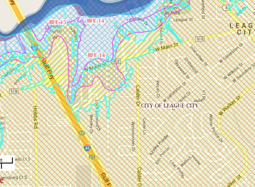
However, that same scary map confirms what almost all of us* already know from our house purchasing adventures (*Centerpointe does include some renters who may not be aware of this stuff): Our subdivision appears to have been mapped as being outside the 100-year flood zone. 
There we are near the bottom right corner.  Most of the action is predictably happening near the top and top left corner, near Clear Creek. 

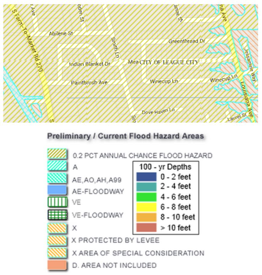
I'm using some worm words in this description because these maps are annoyingly complex to the point where I doubt my own ability to comprehend them correctly.  There are multiple overlapping stipple patterns depending on which layers you activate.
...but if I'm viewing this correctly, I think what they're saying is that we started out being Zone X...

...and we're going to remain Zone X after the new updates are finalized...
But even Zone X is not without certain caveats.  Screengrabbed from this FEMA site. 
BUT GUESS WHAT, DUDES?!  Meadows does not appear to be in the 100-year flood zone either, and yet look again at my photo from 2009 (Meadows is located near the center of this screengrab).   

Screengrabs from RiskMap6 for Galveston County as it was presented in early September 2013.   
Meadows appears to have been mapped in the 500 year flood zone.  Small consolation for the folks who had to make flood claims just four years ago. 

What's the moral of this story?  Why did Meadows flood in 2009?  Why did floodwaters within Meadows take hours to recede after the rain had stopped? 

Once again, the internet irritates me because I can't link to a ready answer.  At the time, there were allegations of plugged drainage conveyances, including one or more downstream conveyances that maybe were supposed to have been maintained by the City of League City.  But the URLs have decayed to the point where I cannot find them now.  As usual, citizen journalists persist where commercial journalists evaporate.  You can watch raw footage of the flooding here, but I can't find the corresponding news reports. 

The moral of that story is that EVERY greater Houston subdivision, without regard to FEMA designation, has the potential to flood IF there is a conspiracy of conditions that thwart the engineered drainage system within or downstream of the subdivision.  And plugged drainage conveyances represent the worst possible scenario. 

To further emphasize the potential we have here in Centerpointe, let's review a blog post I published in May of 2012, in which I humorously documented the fate of our two trash cans during an overnight rainstorm.  Remember that both of these cans were full of trash and recyclables (i.e., heavy) at the time these images were captured, but they still proved to be no match for rising water: 


That wasn't anywhere near the worst rainfall that we might have had, and look what it did!  If you can look at those images above and still conclude that you don't need to voluntarily purchase flood insurance simply because FEMA says you've been mapped in Zone X, you need your head examined!!

Think about it.  That particular heavy rainstorm hit on trash day.  What would have happened if enough of our collective trash had gotten dumped out when rising water tipped over many peoples' cans?  What if it had plugged up our drainage system?  We all got VERY lucky on May 12, 2012, in that we stopped short of that conspiracy of circumstances that could easily have led to more extensive subdivision flooding. 

Here is my best personal-opinion-based advice:  Do not allow yourself to be without flood insurance anywhere on the upper Texas coast, regardless of what your property's official flood risk rating is. 

Do not put grass clippings or any other solid material into our storm sewers, please.  And maybe think about placing your trash cans in your driveway above the curb line if it looks like we might get overnight rain. 

Tuesday, October 30, 2012

If the creek don't rise...

Those of you who read that "City Matters" snail-mail circular that League City sends to all residents may have noticed a provocative article on the fifth page of the October 2012 edition.  Here is a PDF of that (for as long as its link remains active) if you'd like to view it. 

The title of the article is "League City is getting new flood maps", and it's basically an introduction to the fact that the Federal Emergency Management Agency (FEMA) is in the process of remapping Galveston County, apparently in much the same manner as was done for Harris County under an initiative referred to as the Tropical Storm Allison Recovery Project (TSARP; the original FEMA website now re-directs to this Harris County Flood Control District series of pages). 
One of the iconic scenes from Tropical Storm Allison:  The Southwest Freeway's depressed section near Montrose.  Photo from Wikipedia.
Regarding this new mapping initiative, here is an interactive web page that Galveston County residents can review:
Screengrab from:
http://maps.riskmap6.com/TX/Galveston/
Here's a closer-in zoom.  Centerpointe is located just to the right of the scale bar. 
At this point, I will reserve most comments on this new mapping initiative, other than to note that no stippling or color shading changes appear to be affecting Centerpointe subdivision on the maps as they are currently presented on this FEMA site - in particular, none visible on this screengrab above.   

You can expect to hear a lot more about this topic both from League City officials and via commercial news media as the mapping project continues to progress.  I lived in Harris County several years ago during the adoption of the newer TSARP maps and, whoa, things were tense there for quite some time as folks focussed on how the updated flood hazard designations impacted both existing properties and new development interests.  Here is one old Chronicle story (for as long as its URL remains intact) which describes some of what transpired.

Wednesday, February 1, 2012

A new (odd?) search engine result

I frequently Google my own street in order to access a neighborhood map for various purposes (if you check out previous posts, you can see many graphics showing Centerpointe relative to other geographic features).

This morning when I did this, what returned as the top hit was not the usual Googlemaps link or anything close to it - it was a list of individual windstorm certificates published by Texas Department of Insurance.

Screengrabbed from:
https://apps.tdi.state.tx.us/windstormsearch/search_ctrl.jsp?searchCity=&searchCounty=&searchStreet=arl&searchAddNum=7%25

Not all properties are listed here, but as I proceeded to access links, more addresses appeared on the list, as if maybe the database was being populated in real time. 
 What surprises me is NOT that this information is ON the internet, because EVERYTHING is ending up on the internet these days.  What surprises me is that it was the top-ranked hit in Google.  Usually websites migrate to the top of the Google heap because they are the most popular, with the greatest number of user clicks.  Who on earth would care to access this information such that it rises to the top??  I don't know... it might be destined to remain one of the great mysteries of the web. 
From http://www.tdi.texas.gov/wind/maps/index.html
The reason for our relatively high insurance rates.